
Designer: Anton Wallen
Platform: Web Browser
Date Played: May 6, 2014
Game Location: http://www.geoguessr.com/
Explanation
The game is a simple point and click game. The player is provided with an image of some random place in the World. They may look around and even follow the road forward or backward. Using just the image available the player must attempt to figure out where the image was taken in the World. Then the player clicks on a map in the upper right corner of the screen to make a guess. Scores are provided based on how close the guess was to the actual location. This is repeated 4 more times for a total of 5 rounds. Players may create challenges and issue them to friends for an added level of fun. They may also race against the clock to see just how fast they really are.
Screenshot
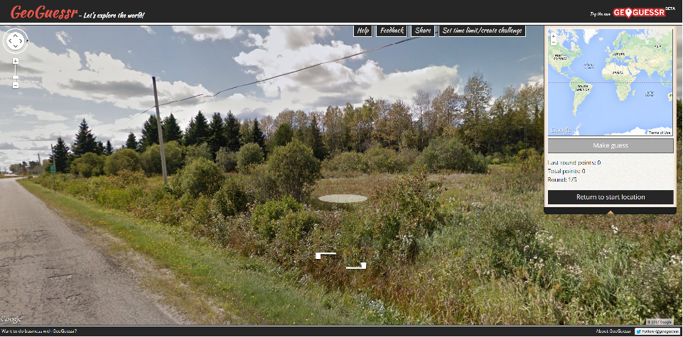
This image shows the play UI for the game. The two arrows near the bottom center are your navigation arrows. They allow the player to travel up and down the road (to a certain extent). Zooming and looking can be performed with the tool in the upper left corner or by using the common mouse functions like click, drag, and scroll. The map in the upper right corner is for making a guess at the location of the image. It too can be zoomed and panned. Beneath the map is the points earned last round, total points, and the round identifier. There is also a reset button that will snap you back to where you were in the image when you first saw it. Across the top of the screen are the Help, Feedback, Share, and Set Time Limit/Create Challenge buttons. The white oval in the center of the image is the mouse indicator, it changes based on the terrain and action you may perform. For example, when it is an oval clicking will cause the image to “jump” to that position, but you are still restricted to the road for the point of view.
Strategy
This game focuses on finding clues about your location. This can be done in many ways:
- Identifying foliage
- Knowledgeable players may use the plant life in the image to determine the location or the region in which the image was taken.
- Determine Driving Direction
- Looking almost straight down a player will see the blurred out vehicle that takes the pictures. While the vehicle is not visible, the blur is, and players can determine what the front of the vehicle is to determine driving direction. Looking for the side view mirrors helps a lot (this is not always possible).
- After determining driving direction players can determine which side of the road the vehicle is traveling on, narrowing the possibilities somewhat.
- Find a vehicle
- Finding a vehicle can be very helpful. Players can look at the shape of the license plate to determine if they are in Europe or not (European plates are long rectangles mostly).
- Find a road sign
- Mile Markers
- Sometimes they will have the mile and highway identifier on them (unless blurred out).
- Speed Signs
- They may identify the highway, but at the very least they will show MPH or KPH which can narrow the results.
- Street Sign
- Finding the name of a street can be helpful; it may even provide a language key to the puzzle.
- Distance Signs
- This is the ultimate find. They may literally tell you the city, the highway, or nearby towns relative to the image position.
- Get Familiar with Google Street View
- Will Oremus suggests getting familiar with Google’s Street View Map. It shows where street view has been, narrowing your search significantly. It is good to know that almost all of Asia is “unviewed” as well as half of South America and most of Africa (2013).
Dynamics
It is difficult if not impossible to receive the maximum score of 32395 because the location selection is VERY sensitive. A player must be within 9 meters of the image location to receive a perfect score per turn (6,479 pts/round).
The unlimited amount of traveling a player is allowed paired with the lack of a time limit in standard play lends itself to cheating via Google searching.
It seems to be impossible to score 0 points, meaning that no matter where the location is a player will receive some sort of score even if they guess in Antarctica repeatedly.
Similar Games
GeoGuessr (Android, clone made by Felipe Caldas), Where Am I?
Design Ideas
This game made me think of a sort of first person survival game where the player is dropped off in a random location and must navigate home or to some preset location. Another idea would be to play the game in reverse. Give the player a location. Then provide a selection of images. The player must try to choose the correct image relating to the location provided. This could be a good casual game on a mobile platform, players could even take pictures themselves and upload them to increase the amount of “challenges” the player has.
Resources
Oremus, W. (2013). How to Beat GeoGuessr, the Insanely Addictive Google Maps Guessing Game. Retrieved from http://www.slate.com/articles/technology/future_tense/2013/05/google_maps_guessing_game_geoguessr_tips_and_cheats_to_beat_the_game.html
